파일:Manchuria.png

Manchuria.png(480 × 395 픽셀, 파일 크기: 440 KB, MIME 종류: image/png)

이 파일은 위키미디어 공용에 있으며, 다른 프로젝트에서 사용하고 있을 가능성이 있습니다. 해당 파일에 대한 설명이 아래에 나와 있습니다.

Warning sign This file requires updating because: Can we have a scholarly source on the northern limit and the general territorial scope of the Outer Manchuria concept? The map has been reverted several times because of Sakhalin Island. In doing so, you could add a timestamp to the file.
Please notify the uploader with {{subst:update-note|1=File:Manchuria.png|2=Can we have a scholarly source on the northern limit and the general territorial scope of the Outer Manchuria concept? The map has been reverted several times because of Sakhalin Island.}} ~~~~

파일 설명

설명
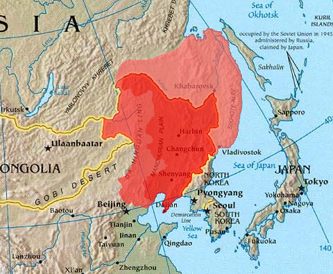
English: Map of Manchuria. See en:Manchuria for a description of the dark, medium, and light red areas.
 
Inner Manchuria.
 
North region of Inner Mongolia.
 
Areas ceded to Russia in 1858 & 1860 (sometimes called Outer Manchuria).
中文(简体):满洲/东北地区地图。浅/中/深红地区在zh:满洲一文中有详尽的解释。
हिन्दी: मंदछुरिया
출처 The World Factbook
저자 CIA
다른 버전

라이선스

Public domain
이 그림은 미국 중앙정보부(CIA)에서 발간하는 월드 팩트 북(World Factbook)에 수록되어 있는 퍼블릭 도메인입니다.

Bahasa Indonesia  čeština  Deutsch  eesti  English  español  Esperanto  français  galego  hrvatski  italiano  Nederlands  norsk nynorsk  polski  português  sicilianu  slovenščina  suomi  Türkçe  Zazaki  беларуская (тарашкевіца)  македонски  русский  српски / srpski  українська  ქართული  বাংলা  தமிழ்  മലയാളം  한국어  日本語  中文  中文(简体)  中文(繁體)  العربية  +/−

설명

이 파일이 나타내는 바에 대한 한 줄 설명을 추가합니다

이 파일에 묘사된 항목

다음을 묘사함

파일 역사

날짜/시간 링크를 클릭하면 해당 시간의 파일을 볼 수 있습니다.

날짜/시간크기사용자설명
현재2023년 12월 21일 (목) 18:32480 × 395 (440 KB)KwamikagamiReverted to version as of 12:53, 21 March 2005 (UTC) -- last good version. Urup is not claimed by Japan.

다음 문서 1개가 이 파일을 사용하고 있습니다: