미리 보기 크기: 600 × 600 픽셀 다른 해상도: 240 × 240 픽셀 | 480 × 480 픽셀 | 705 × 705 픽셀
원본 파일 (705 × 705 픽셀, 파일 크기: 135 KB, MIME 종류: image/png)
이 파일은 위키미디어 공용에 있으며, 다른 프로젝트에서 사용하고 있을 가능성이 있습니다. 해당 파일에 대한 설명이 아래에 나와 있습니다.
파일 설명

|
이 그림은 벡터 그래픽 버전(SVG)이 있습니다. 래스터(비트맵) 그림 대신 벡터 그래픽 그림을 사용하는 것이 좋습니다.
File:China map.png → File:China map.svg
|
| 설명China map.png |
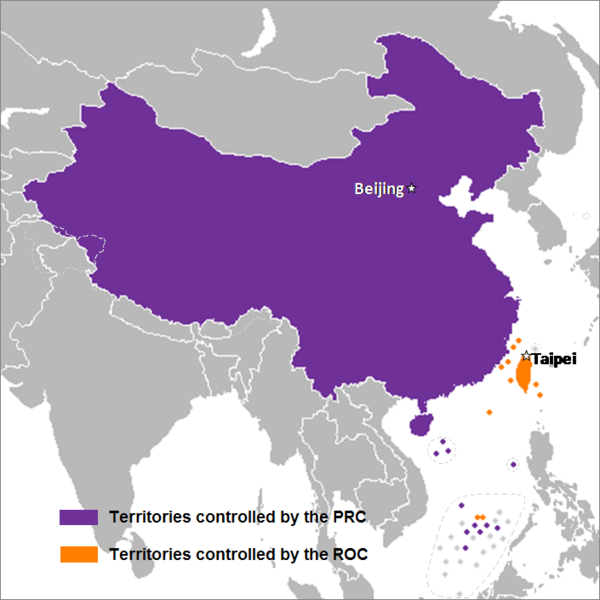
English: This is a map of the two states that officially use the name "China" in their names and depicts the actual "line of control" and not any claims that states often make. Key words: actual administration and actual maintaining of control of the territories.
中文(简体):这是一个关于两个都把“中华”用在自己的国名里的国家的地图,这个地图描绘了两国的实际“控制线”并跟两国通常声称的完全不是一回事。关键词:实际管辖和维持实际控制区域。
中文(繁體):這是一個關於兩個都把“中華”用在自己的國名裡的國家的地圖,這個地圖描繪了兩國的實際“控制線”並跟兩國通常聲稱的完全不是一回事。關鍵字:實際管轄和維持實際控制區域。 |
| 날짜 | 2007년 9월 24일 (원본 올리기 일시) |
| 출처 | Sreejithk2000 사용자가 CommonsHelper 도구를 사용하여 en.wikipedia에서 공용으로 옮겨왔습니다. |
| 저자 | 영어 위키백과의 Nat |
라이선스

|
GNU 자유 문서 사용 허가서 1.2판 또는 자유 소프트웨어 재단에서 발행한 이후 판의 규정에 따라 본 문서를 복제하거나 개작 및 배포할 수 있습니다. 본 문서에는 변경 불가 부분이 없으며, 앞 표지 구절과 뒷 표지 구절도 없습니다. 본 사용 허가서의 전체 내용은 GNU 자유 문서 사용 허가서 부분에 포함되어 있습니다.http://www.gnu.org/copyleft/fdl.htmlGFDLGNU Free Documentation Licensetruetrue |
이 파일은 크리에이티브 커먼즈 저작자표시 3.0 Unported 라이선스로 배포됩니다.
- 이용자는 다음의 권리를 갖습니다:
- 공유 및 이용 – 저작물의 복제, 배포, 전시, 공연 및 공중송신
- 재창작 – 저작물의 개작, 수정, 2차적저작물 창작
- 다음과 같은 조건을 따라야 합니다:
- 저작자표시 – 적절한 저작자 표시를 제공하고, 라이센스에 대한 링크를 제공하고, 변경사항이 있는지를 표시해야 합니다. 당신은 합리적인 방식으로 표시할 수 있지만, 어떤 방식으로든 사용권 허가자가 당신 또는 당신의 사용을 지지하는 방식으로 표시할 수 없습니다.
이 라이선스 중에서 목적에 맞는 것을 선택하여 사용할 수 있습니다.
기존 올리기 기록
The original description page was here. All following user names refer to en.wikipedia.
- 2008-05-29 22:44 Shibo77 705×705× (136871 bytes)
- 2008-05-29 21:59 Shibo77 705×705× (135686 bytes)
- 2008-05-29 21:53 Shibo77 705×705× (132630 bytes) Reverted to version as of 00:46, 16 May 2008
- 2008-05-29 08:51 Sontung007 556×537× (31782 bytes) Reverted to the neutral version to avoid disputes and ambiguity
- 2008-05-16 00:46 Taktser 705×705× (132630 bytes)
- 2008-05-16 00:44 Taktser 705×705× (132710 bytes)
- 2008-05-03 20:22 T-1000 705×705× (115888 bytes) Reverted to version as of 22:31, 4 April 2008
- 2008-04-08 17:10 Heavyrain2408 705×705× (129360 bytes) Chinese people use tricky word "administration" to mislead readers to believe these islands belonging to them. Please stop these kinds of actions.
- 2008-04-04 22:31 Taktser 705×705× (115888 bytes) Reverted to version as of 20:02, 27 March 2008 (administration is clearly stated, not the question of sovereignty over these territories, Arunachal Pradesh is excluded; Aksai Chin, the Spratly islands and some of the Paracel islands are included)
- 2008-03-30 05:36 Heavyrain2408 705×705× (129360 bytes) Constroversary parts should not be included. This could result readers think that these parts belong to China.
- 2008-03-27 20:02 Taktser 705×705× (115888 bytes) Reverted to version as of 20:31, 10 March 2008 It's clearly stated as administration not sovereignty
- 2008-03-21 21:11 Sontung007 705×705× (129360 bytes) the previous map wrongly included unresolved disputed islands
- 2008-03-10 20:31 Taktser 705×705× (115888 bytes) Reverted to version as of 16:33, 16 November 2007
- 2008-01-24 15:26 Sinoevils 705×705× (129360 bytes) This is the real China Map
- 2008-01-24 15:24 Sinoevils 705×705× (129360 bytes) This is the real China Map
- 2007-11-16 16:33 Nat 705×705× (115888 bytes)
- 2007-11-06 18:53 Nat 556×537× (30702 bytes)
- 2007-11-05 22:48 Nat 556×537× (33377 bytes)
- 2007-10-28 07:25 Jjhcap99 556×537× (31782 bytes) Added country names.
- 2007-10-19 22:35 Jerrch 556×537× (30043 bytes) Capitalized the capitals
- 2007-10-16 22:23 Nat 556×537× (30403 bytes) Reverted to version as of 19:37, 9 October 2007
- 2007-10-16 20:34 Jerrch 556×537× (30411 bytes) Reverted to version as of 19:56, 29 September 2007
- 2007-10-15 13:05 Jjhcap99 556×537× (33989 bytes)
- 2007-10-09 19:37 Nat 556×537× (30403 bytes) This is the work of {{user|Nat}}
- 2007-10-09 19:32 Nat 556×537× (32238 bytes) This is the work of {{User7|Nat}}.
- 2007-09-29 19:56 Jerrch 556×537× (30411 bytes) changed color a little bit to make it just a little more neutral.
- 2007-09-24 23:16 Nat 556×537× (30343 bytes)
- 2007-09-24 01:44 Nat 1127×1069× (958918 bytes)
| 주석 InfoField | 이 이미지에는 주석이 있습니다: 공용에서 주석을 보기 |
62
589
375
38
705
705
English: Territories controlled by the PRC
中文(臺灣):中華人民共和國政府實際控制領土
中文(中国大陆):中华人民共和国政府实际控制领土
吴语:中華人民共和國政府實際控制領土
63
631
375
40
705
705
English: Territories controlled by the ROC
中文(臺灣):中華民國政府實際控制領土
中文(中国大陆):中华民国政府实际控制领土
吴语:中華民國政府實際控制領土
412
209
82
28
705
705
English: Beijing
中文:北京
吴语:北京
606
407
81
27
705
705
English: Taipei
中文(臺灣):臺北/台北
中文(中国大陆):台北
吴语:臺北
설명
이 파일이 나타내는 바에 대한 한 줄 설명을 추가합니다
China(中國)
中国的地图
이 파일에 묘사된 항목
다음을 묘사함
24 9 2007
image/png
138,578 바이트
705 화소
705 화소
파일 역사
날짜/시간 링크를 클릭하면 해당 시간의 파일을 볼 수 있습니다.
| 날짜/시간 | 크기 | 사용자 | 설명 | |
|---|---|---|---|---|
| 현재 | 2014년 12월 15일 (월) 15:14 | 705 × 705 (135 KB) | Shibo77 | .. |
이 파일을 사용하는 문서
다음 문서 1개가 이 파일을 사용하고 있습니다:


